
invites you to participate in a MapRun Navigation Challenge in
South Burdon Wood
|
|
Cleveland Orienteering Klub invites you to participate in a MapRun Navigation Challenge in South Burdon Wood |
|
Follow this link for an introduction to MapRun Navigation Challenges.
STOP PRESS
During the current wet weather, it's become rather difficult to get to some of the control sites. (Standing water, slippery slopes, etc.) Phill Batts has therefore devised "winter versions" of the courses. See below.
Location
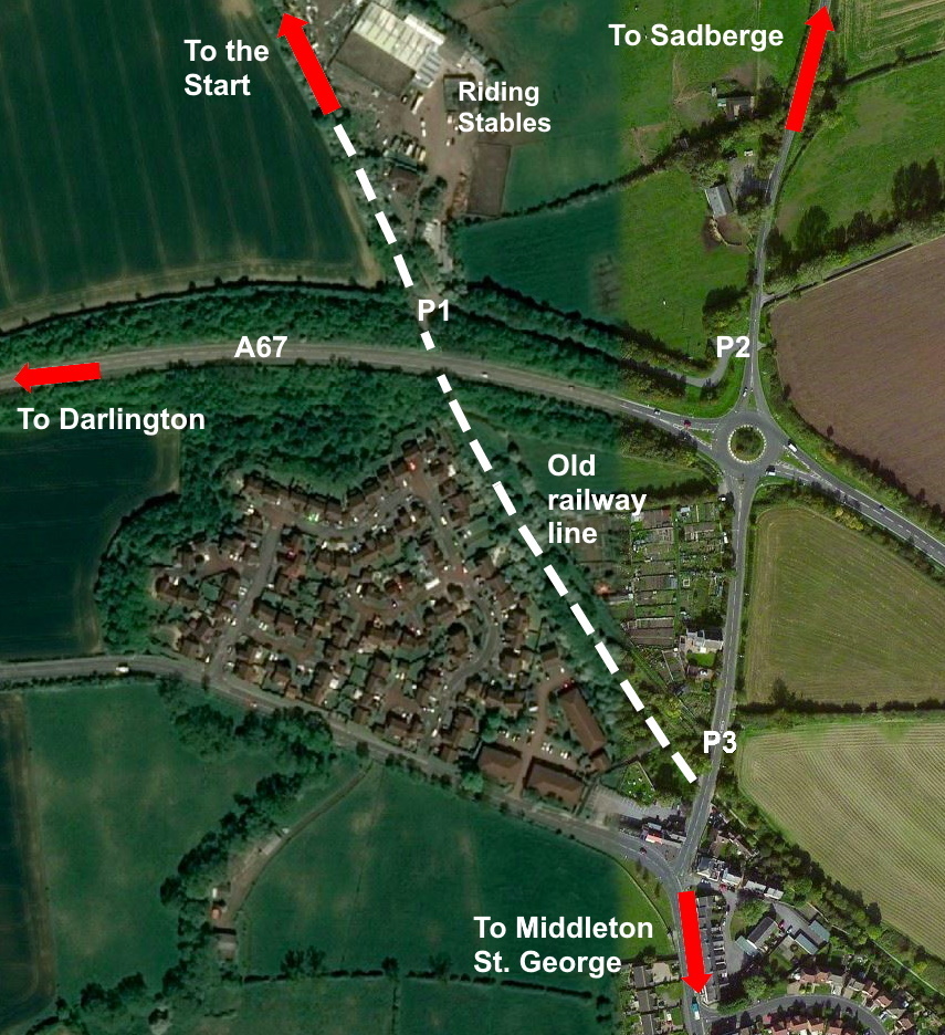
The Start is south-west of the old railway line (now a bridleway) between Middleton St. George and Darlington.
Click on the link to see a map. You can zoom in (and, optionally, switch to Satellite mode) to see the details of the final approach to the event. You can also get directions if you put in your starting location.
You should be able to park at either end of the lane that leads from Sadberge Road to where the old railway line passes under the A67. See this satellite image.
There is a riding stables at the end of the lane, so if you're parking on the lane please make sure that you leave plenty of space for horse boxes to get past.
From the underpass where the old railway line passes under the A67, walk (or jog) north-west along the old railway line. After 700m you'll go under some pipelines. Under the pipelines, turn left off the old railway line and follow a small path up the bank. If you're using your smartphone, the MapRunF app will show you a 'red beetle trail' leading to the Start. (After you pass through the Start the app will stop showiing your location!)
Terrain
The competition area is a new forest plantation with blocks of semi-mature trees. There is a complex path network, and the area is bisceted by an old railway line. There is some contour detail, especially around the numerous ponds.
Please note that:-
Courses
In the MapRunF app, Select Event and look for your preferred course (see below) under UK / County Durham / Darlington / South Burdon VOC.
There are four courses. Please note that this area cannot support a high level of navigational difficulty, so the Long, Medium and Short courses are all TD3 (i.e. similar to an Orange colour coded course). The Beginners course is TD2 (i.e. similar to a Yellow colour coded course).
| Course | Length | Climb | Controls | ||
| Long | 7.8 km | 50m | 21 | Map | |
| Medium | 5.7 km | 40m | 17 | Map | |
| Short | 4.1 km | 30m | 14 | Map | |
| Beginners | 2.7 km | 15m | 12 | Map |
Winter versions of the courses
| Course | Length | Climb | Controls | ||
| Long | 7.8 km | 50m | 21 | Map | |
| Medium | 5.7 km | 40m | 17 | Map | |
| Short | 4.2 km | 30m | 14 | Map | |
| Very Short | 3.0 km | 30m | 13 | Map |
Paper maps
If you'd prefer to use a paper map rather than the one on your smartphone (which is going to be quite small and can be tricky to see in bright sunlight) you can use the link below to download a PDF copy of the map and print it off at home. If you don't have a suitable printer, Lorraine Batts is offering a map printing service.
Results
You can access the results via the MapRun Console. Open the menu (three horizontal lines at the top left hand corner of the window), select Leader Board and then filter by South Burdon.
Facilities
There are no public toilets near the Start. Please make your own arrangements. There are customer toilets in the Morton Park Morrisons.
Organiser
Caroline Mackenzie
Planner
Phill Batts
Safety
Please ensure you use a buddy system so that someone knows when you should return.
Please be courteous to members of the public in the competition area.
Remember to comply with Government guidance on social distancing. For one thing, permission to continue to organise these callenges depends on participants being clearly seen to be following the coronavirus rules. Also, from your own point of view, it's not worth risking catching Covid-19 just to save a few seconds on a navigation challenge.
Go to the CLOK home page