
invites you to a Regional event in
Silton Forest
on Sunday 22nd March 2026
|
|
Cleveland Orienteering Klub invites you to a Regional event in Silton Forest on Sunday 22nd March 2026 |
|

| This event is participating in the Red Runners promotion. Follow the link for more information. |
| Location: |
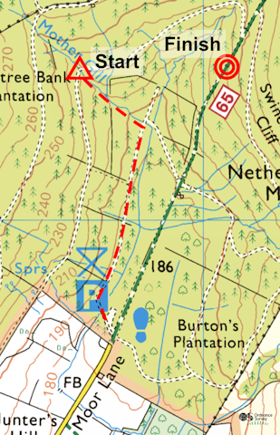
Parking will be in the Silton Forest public car park at grid reference SE 467936. The postcode is YO7 2LL and the What3words reference is ///purified.badly.storm. Click on the link to see a map. You can zoom in (and, optionally, switch to Satellite mode) to see the details of the final approach to the event. You can also get directions if you put in your starting location. The event will be signed from Over Silton and Nether Silton. If you are coming from the south on the A19, you may like to consider travelling north to the junction with the A684, where it's possible to cross under the A19, as this avoids a right turn across the dual carriageway. The final approach to the car park is along Moor Lane, which is a single track road with few passing points. To reduce traffic issues, we recommend that you aim to arrive before 11:30 a.m. and only leave after 12 noon. Also, you will encounter both competitors and dog walkers on the road as you approach the event. Please take extra care and be courteous towards pedestrians. We would have preferred to park along the verges of Moor Lane and leave the car park for the (numerous) dog walkers. If you are accosted by an irate dog walker, please (a) keep calm and polite and (b) explain that we are only using the car park because Forestry England told us to. The exit is back south along Moor Lane. Enquiries / Download will be close to the car park. | |||||||||||||||||||||||||||||||||||||||||
| Terrain: |
Silton Forest is a large working forest spanning two large spurs and rising from the Silton villages up the North York Moors scarp slope to Hambleton End and Thimbleby Moor. There are areas both coniferous and deciduous forest. There are some excellent rock features. The forest has a network of forestry tracks and some mountain bike routes but has few walking paths. Off the tracks and paths, the wood is rather wild and sees little footfall. In recent years, clear felling has taken place, and the felled areas have re-wilded with gorse, brambles and self-seeded trees overlying brashings. In other words, they may present challenging route choices! This event has been planned using different parts of the forest to those used previously in order to maximise the use of mature areas and to offer route choices around the clear fell or dense immature forest areas. (The courses have been planned to avoid areas thinned by recent harvesting operations.) Brambles and dead bracken can be high, and for this reason we recommend you wear full body cover (i.e. arms covered too). You can view the map from the most recent previous event (2023) on RouteGadget. | |||||||||||||||||||||||||||||||||||||||||
| Courses: |
Sorry. Due to Forestry England restrictions, we are unable to provide a White course at this event. | |||||||||||||||||||||||||||||||||||||||||
| Map: |
Scale as in the table above. 5m contours. Control descriptions will be printed on the maps, and loose copies will be available at the Start. The control descriptions for the Red, Orange and Yellow courses will be both pictorial and written. The control descriptions for the other courses will be pictorial only. | |||||||||||||||||||||||||||||||||||||||||
| Punching system: |
SPORTident electronic punching will be used. The control boxes will be activated to enable SIAC cards to operate in touch-free mode ..... but please note that you will need to punch the conventional way at the Start and Finish. If you need to hire an SI-card (£1), please order it via the Racesignup online entry system and collect it from Download before your run. Remember to return it as you download, and take care of it, as there will be a £20 charge if you lose it. A limited number of SI-cards will be available for hire on the day, but please pre-order via the online entry system if at all possible. | |||||||||||||||||||||||||||||||||||||||||
| Entries: |
If you wish to participate in this event, please pre-enter via the Racesignup online entry system.
The entry deadline is midnight on Thursday 12‑Mar‑2026. After that, you will still be able to enter until midnight on Thursday 19‑Mar‑2026, but there will be a £2 late entry surcharge for Seniors and your choice of course may be limited by map availability. There will be very limited entry on the day subject to the availability of maps (and, of course, the late entry surcharge) ..... but please make every effort to pre-enter if you possibly can. | |||||||||||||||||||||||||||||||||||||||||
| Starts: |
10:30 a.m. - 12:30 p.m. Courses close at 2:30 p.m. The Start is about 900m from the car park, with 45m climb. Follow the red-and-white tapes and allow about 20 - 30 minutes depending on your walking speed. The walk from the Finish back to the car park is about 900m, all either downhill or on the level. Please remember to Download when you get back. |
| ||||||||||||||||||||||||||||||||||||||||
| Facilities: |
Toilets near the car park. No drinks will be provided at the Finish. Please bring your own refreshmenbts. First Aid at Download. | |||||||||||||||||||||||||||||||||||||||||
| Dogs: | Well behaved dogs on leads are welcome in the parking area. You can walk your dog in the forest but, if you do so, please take care not to inconvenience other competitors on their runs. Dogs are not allowed on the courses. | |||||||||||||||||||||||||||||||||||||||||
| Officials: |
| |||||||||||||||||||||||||||||||||||||||||
| Photography: | Anyone taking photos or videos at this event must do so in accordance with CLOK's Photography and Filming Policy. | |||||||||||||||||||||||||||||||||||||||||
| Insurance: |
British Orienteering members are covered by British Orienteering's public liability insurance while participating in this event. Non-members are not covered. Note: Public liability insurance covers you against liability for causing harm to someone else. For example, it would cover you if you were sued for accidentally injuring a member of the public or causing damage to property during the event. It's fair to say that most people go through life without worrying about public liability insurance. | |||||||||||||||||||||||||||||||||||||||||
| Safety: |
A comprehensive risk assessment will have been carried out by the Organiser, but please remember that competitors take part at their own risk. Orienteering is an adventure sport – your safety while orienteering is your own responsibility. Please make sure that you download even if you do not complete your course. CLOK strongly recommends that you carry a whistle while participating in this (and every) orienteering event. If you have a relevant medical condition, please add this to your competitor details in Racesignup. Any information provided will be treated in strict confidence and will only be used if you need medical treatment and are unable to communicate at the time. | |||||||||||||||||||||||||||||||||||||||||
Go to the CLOK home page